Ancient navigators faced incredible challenges. Among those were simply knowing where they were and how to safely return home. The magnetic compass was first used at sea in 1117 but mariners were sailing the seas long before that time. What guided these brave explorers? The sky, of course.
As stated in an earlier section, we map the globe with lines to determine our latitude and longitude. Accurately knowing these values often meant the difference between fame or failure and even life or death.
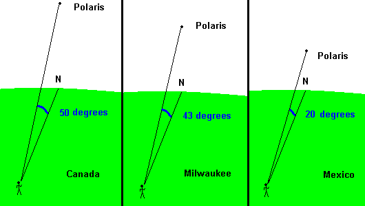
Your latitude is actually quite easy to determine. All you have to do is locate Polaris and measure the angle it makes with the (northern) horizon. This angle is always equal to the observer's latitude.
An explorer in the northern hemisphere will always be able to see Polaris and use an astrolabe, cross-staff, or sextant to measure this angle. It was a bit trickier if the explorer was on a boat since the rocking boat made accurate measurements difficult.
a sextant
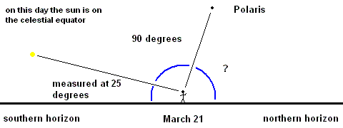
If the explorer was near or below the equator; however, Polaris will not be in the local horizon so you use plan B - the sun. Each day when the sun is on the meridian, it reaches its highest position of the day. The position of the sun on the meridian varies from day to day (remember the ecliptic); however, its displacement from the celestial equator is known for every day of the year. So explorers would measure the position of the sun when it was on the meridian ... and from there, be able to calculate their latitude. We will do this in a lab class or as a discussion board topic. To give you an idea how this works, imagine you are in the northern hemisphere, it is March 21, and you find that the sun makes a 25 degree angle with the southern horizon when it rests on the meridian. You know the sun is exactly on the celestial equator that day and you also know that the celestial equator is 90 degrees from the celestial north pole (Polaris). Using simple geometry, one can calculate the angle between Polaris and the northern horizon must be 65 degrees ... giving you the latitude.
Finding longitude was much harder for early navigators than finding the latitude. In early cases, all a navigator could do was guess. A sailor estimated east-west distance traveled by measuring the speed of the boat relative to the water. This method did not take into account surface ocean currents and drifting of the boat. This is why many early maps showed the most distortions in the east-west direction.
Astronomers knew that the key to measuring longitude accurately was time. Here are some facts astronomers use to find longitude:
The Earth rotates a full 360 degrees in one day.
This equals 15 degrees of rotation per hour.
This also means that Earth rotates one degree every 4 minutes.
This produces the diurnal motion in the sky that one routinely observes (sun rise and sun set).
Your view of the sky depends on both location and time.
High noon (local noon as read by a sundial) occurs when the sun rests on your meridian.
Greenwich, England is the base from which we measure longitude.
Milwaukee is 88 degrees west of Greenwich, so that is our longitude.
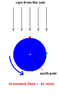
Suppose an explorer was in Milwaukee and wanted to determine the longitude of this location. You would need to know the time (as read by a sundial) in two locations - Greenwich and Milwaukee. The Milwaukee time would be easy! Set up a sundial and read it. But how would you know Greenwich time at that same instance? One way is to carry a very accurate clock set to Greenwich time and read it! To make this example as easy as possible, you would look at this clock (set to Greenwich time) when the sun is on the Milwaukee meridian (high noon). Your Greenwich clock would read 5:52 pm. and the sundial in front of you would read 12 noon (see the animation below). This means that 5 hours and 52 minutes (or 352 minutes) have passed since the sun was on the Greenwich meridian ... meaning Earth has rotated 352/4 ... specifically 352 minutes divided by 4 minutes/degree = 88 degrees since that time ... so you are 88 degrees west of Greenwich!
longitude animation
This sounds easy, but early navigators really didn't have accurate clocks to keep Greenwich time as they sailed to new lands ... or did they? When Galileo discovered 4 tiny moons orbiting Jupiter in 1609, he opened the door for finding a unique way of determining the time at Greenwich. By 1668, Gian Domenico Cassini computed the orbital properties of these moons which would allow an observer to match their position with Greenwich time. These tiny moons became a "sky clock" of sorts. All an explorer needed was a telescope, a view of Jupiter, and Cassini's conversion tables to know the exact time at Greenwich. However, this method would not work if the explorer was sailing on a boat (because of the constant rocking made observations impossible). The problem of finding longitude while at sea was one of the greatest scientific challenges in the 1700's. England offered a reward of 20,000 £ (pounds) to anyone who could solve this problem. A self-taught clockmaker named John Harrison eventually won the prize when he perfected pocket watches to uncanny accuracy.
Today anyone can get the exact longitude and latitude using a GPS (Global Positioning System). Orbiting around Earth are a couple dozen satellites which allow you to use their signals to triangulate and fix your location to within a few feet. If interested, click here to learn how this system works.
©Jim Mihal 2004, 2014, 2023 - all rights reserved