This would be an excellent time to learn the Stellarium program. See the assignments folder in Blackboard. You will have a virtual sky at your fingertips which lets you insert all the reference lines in the sky (meridian, horizon, celestial equator, etc). You can add the grid markings for right ascension and declination. When you click on or search for an object, it will give you its astronomical coordinates.
Why wait? Anyway, you are required to learn the program for this class! Why not now when it is the most helpful?
When you stand outside on a star filled night, it can be a humbling experience. It can sometimes invoke questions about our role in the "big picture" which crosses philosophical and religious lines. The grandeur and vastness of the cosmos has had similar effect on man throughout the ages. As you stand and watch the night sky it is as if you were in the "inside" looking out! All the stars (to you) appear as distant points of light .... well beyond your reach. You have absolutely no depth perception ... so, as far as you are concerned, they could all be the same distance from you. You should already know that this is not true. The distance to stars may be vast, but it does vary from star to star. However, we will adopt this model of the universe for now because it allows us to treat the sky like a big sphere ... and you can draw lines on spheres and develop coordinate systems.
The Celestial Sphere
If you examine the image above, you will see that the "universe" is depicted with Earth at the center, and all the stars lie on the "celestial sphere". Before we attempt to examine the lines astronomers draw on the celestial sphere, we should first review the ways geographers draw lines on the globe.
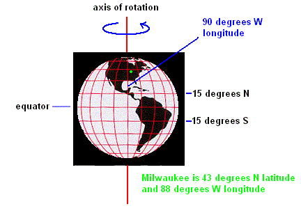
It is no secret that Earth spins on its axis. This motion is known as rotation. As it does so, it defines natural reference points such as the north and south poles. Midway between is the equator. Geographers draw horizontal lines on Earth which are parallel with the equator and then use these lines to determine the latitude of any given spot on Earth. The equator is the base line and is given a latitude of 0 degrees. Using this system, Milwaukee is 43 degrees north of the equator in latitude.
Lines are now drawn from the north pole to the south pole on the globe (known as meridian lines). These lines are used to determine the longitude of any point of Earth. By convention, the vertical line drawn through Greenwich England is chosen to represent the base line from which longitude is measured and is known as the prime meridian. Since Milwaukee is found 88 degrees west of the prime meridian, the longitude of Milwaukee is 88 West. Any point on Earth can be precisely located using coordinates of latitude and longitude.
Celestial Pole and Celestial Equator
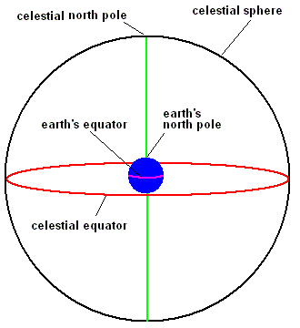
If you extend Earth's equator into the sky and project it onto the celestial sphere, it becomes a great circle known as the celestial equator (just called equator in Stellarium). Likewise, extending Earth's axis of rotation to the sky defines the celestial poles (north and south).
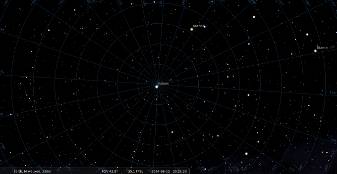
This is a screen capture of the north celestial pole in Stellarium. It is where all the lines converge. If you have Stellarium loaded, add the equatorial grid (menu item on bottom which looks like a globe). Next, use the left menu item - Sky and Viewing Options, then Markings tab to check Celestial Poles (of date). If you zoom in at Polaris you will actually see that Polaris is very close to the north celestial pole but not exactly at the same point .... but close enough. This is just a fortunate coincidence for us in our lifetime. Later you will discover that these two points in the sky will be very far apart for sky viewers in the distant future.
This is a screen capture of a small section of the celestial equator in Stellarium. Stellarium simply refers to the celestial equator as "equator" as indicated in the picture (don't worry about the other stuff in the picture .... yet). Simply use the left menu item - Sky and Viewing Options, then Markings tab to check Equator (of date).
Declination
Astronomers use the celestial equator as a base line to measure objects in the sky in the north/south direction (similar to the way geographers use Earth's equator to determine latitude). This measurement, known as declination, is measured in degrees from the celestial equator. Positive numbers indicate north and negative numbers measure south of the celestial equator.
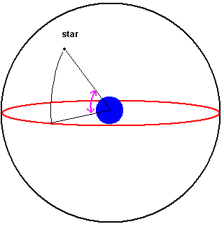
Declination
You can see these grid marking on your sky chart or in the Stellarium program (see image above). Declination is measured in degrees. If you know an object's declination, you are halfway to pin-pointing it on the celestial sphere.
The Vernal Equinox
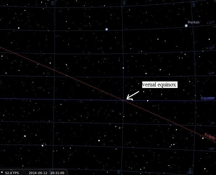
Look back at the Stellarium screen capture and you will see I have one point labeled vernal equinox. It is also at the exact center of the SC001 sky chart. This point in the sky lies on the celestial equator. There really isn't anything interesting there. I have another line shown, ... known as the ecliptic. We will discuss that line later. I put it in because these two lines intersect at the vernal equinox.
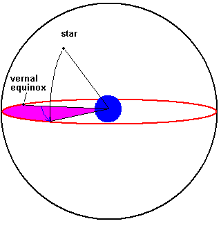
Right Ascension
The vernal equinox is a point on the celestial equator that astronomers use as a reference for measuring east/west in the sky. The right ascension is the distance (measured along the celestial equator in an eastward direction) an object is displaced from the vernal equinox. The units are not in degrees, but rather time units of hours, minutes, and seconds. As you might guess, it takes 24 hours to go a full 360 degree circle along the celestial equator (starting at the vernal equinox). Note: East is to the left on a sky chart!!!!
Using Stellarium, you should see the markings for right ascension. In Stellarium you need to add the equatorial grid and the markings appear along the perimeter of the screen. Zoom in to get finer details.
Right Ascension
Using this system of right ascension and declination, an astronomer can map the sky just as a geographer uses longitude and latitude to map the globe. If one only needs to obtain an approximate location in the sky, constellations will get you close. However, if you want an exact fix on an object, look up the objects declination and right ascension. Below are some coordinates of some stars as they might appear in a journal or astronomy book:
| Star | Declination | Right Ascension |
| Aldebaran | +16 30 33 | 04 35 55.2 |
| Arcturus | +19 10 57 | 14 15 39.7 |
| Antares | -26 25 55 | 16 29 24.4 |
+16 30 33 means 16 degrees, 30 arc minutes, 33 arc seconds (north) . An arc minute is 1/60 of a degree and an arc second is 1/60 of an arc minute. 04 35 55.2 means 4 hours, 35 minutes, 55.2 seconds east of the vernal equinox. Notice that the star Antares is south of the celestial equator.
In Stellarium, all you have to do is click on any star and you should see the RA/DE (on date) in the upper left (somewhere in the long list of data). Right click and it goes away.
Click here if you want to read more about right ascension and declination.
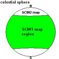
Please refer to your constellation map - SC001 star map (if purchased). A section is displayed here and the whole thing is displayed here.
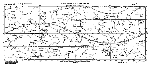
Since it is quite impractical to work off a 3 dimensional celestial sphere, we can project the majority of the celestial sphere on a 2 dimensional surface. The SC001 sky map represents the majority of the sky (to ± 60 from the celestial equator) where the left edge matches up with the right edge (forming a cylinder like shape). Your position is in the center.
Notice that the direction east is to the left. This is standard for all sky maps and you can see why if you hold the map above your head with the top facing north (or you simply look up as you face south). You will see that east is to your left. The horizontal line across the center of the page represents the celestial equator with the vernal equinox at the exact center of the map. Looking along the celestial equator, you should see marking for right ascension (starting at the vernal equinox and increasing to the east). There are several vertical lines with degree markings to indicate declination. Please take the time to confirm the coordinates (to the limits possible) for the stars Aldebaran, Arcturus, and Antares. (Note: declination to the nearest degree and RA to within 5 minutes)
This map depicts the northern section of the celestial sphere. The north celestial pole is at the "bulls eye". Notice that there is a star (Polaris) located very close to this point.
Since we are standing on Earth, it becomes impossible to see the entire celestial sphere at once (unless you can see through the ground). In fact, from any one location on Earth and at any single time, you can only view half of the celestial sphere. This defines an observer's local horizon. Notice that astronomers are not concerned if it is day or night, flat or mountainous or even cloudy ... you always have half of the celestial sphere in your horizon. It should be obvious that your view of the celestial sphere depends on your location on Earth ... but it also (usually) depends on what particular time you happen to be observing.
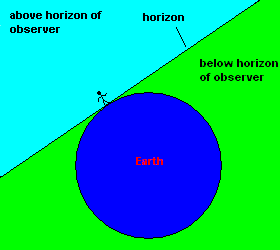
The Earth blocks half our view of the celestial sphere.

Your Local Horizon
There are some references to the local horizon that you should know. The zenith is the point directly over your head (straight up). The meridian (celestial meridian) is a line which extends from your northern horizon, through the zenith, and down to the southern horizon. The meridian divides the sky in half. Astronomers are always interested in knowing when objects are at or near the meridian because they are forced to view the sky through a thin atmosphere. However, when a celestial object is on the meridian, it passes through the least amount of atmosphere ... providing the best view of that object. Stellarium lets you mark all these lines in the sky (Sky and Viewing Options, then Markings tab).
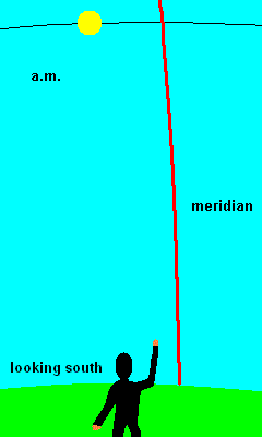
a.m. - p.m. animation
You make reference to the meridian almost each and every day. An appointment at 11:40 a.m., means "ante meridian" which is Latin for "before" the sun crosses the meridian ... and p.m. means "post meridian" which indicates the sun has past the meridian. Local noon (local apparent time or high noon) occurs when the sun crosses the meridian. At this time, a sundial would read 12:00 (we will see later that the wall clocks usually read something else).
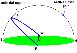
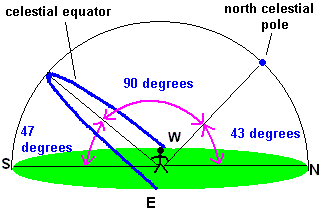
Milwaukeeans live about half way between Earth's north pole and equator and we see the sky a bit different than our neighbors to the north or south. Our latitude is 43 degrees north, and as a result, we find the north celestial pole 43 degrees above our northern horizon. This is not a coincidence ... the angle between the (north) celestial pole and the (northern) horizon will always equal your latitude! The celestial equator is always found 90 degrees from the north celestial pole. Using simple math, you should see that (in Milwaukee) the celestial equator is found 47 degrees above our southern horizon
If you live in Canada, you would find the north celestial pole closer to the zenith. If you live in Mexico, the north celestial pole is found much closer to the northern horizon.
Stellarium users can easily see this. Set your location to Milwaukee and watch a day go by in a matter of minutes. Let this happen as you look in all the cardinal directions (East, South, West, and North). Now look north, lock on Polaris, and zoom out so you see the horizon. As you watch the sky, bring up the Azimuthal Grid (looks like a spider web) and note how everything makes circles around Polaris as time flies by. Then note how many degrees Polaris (actually the north celestial pole) is from the horizon. I'll bet the program will show that the north celestial pole is 43 degrees from the horizon. Hey .... that's the latitude of Milwaukee!!!!
I made a video (for another class) which shows you how to find your latitude using Polaris in Stellarium. This video will help you learn some features of Stellarium but you already know that the angle Polaris makes with the horizon is always equal to your latitude. You can stop at the "proof" if you like. Find that video here.
Please do the Stellarium assignment NOW. Look in the assignments section, download the program (or do the "less powerful" web version if you have problems). Watch the short video I made on the program and try the exercises I've suggested. Then contact me. We will do a video chat where I evaluate your mastery of the program. It goes quick (if you are prepared) and it also gives us a chance to actually meet each other. We also do something similar for the final exam so this gives you a good chance to discover how that all works. It works best if you have the Chrome browser loaded on the same computer you have the Stellarium program on. You get an incredible "early bird" bonus if you do this assignment NOW. Stellarium is a great tool to help you learn how the sky is mapped and changes on different time scales.
©Jim Mihal 2004, 2014, 2019, 2023 - all rights reserved