

See this
animation
The Chinese philosopher Chang Hêng invented the earliest known
device to measure earthquake intensity in 132 A.D. On the outside of the
vessel
there were eight dragon-heads, facing the eight principal directions of
the compass. Below each of the dragon-heads was a toad, with its mouth
opened toward the dragon. The mouth of each dragon held a ball. At the
occurrence of an earthquake, one of the eight dragon-mouths would release
a ball into the open mouth of the toad situated below. The direction of
the shaking determined which of the dragons released its ball. The instrument
is reported to have detected a four-hundred-mile distant earthquake.

Chang Hêng's earthquake weatherclock
Geologists now use a seismograph to measure earthquake intensity.
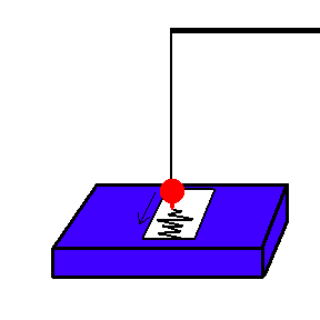
How a seismograph works (animation)
During an earthquake, the earth vibrates under a "stationary" pendulum
... recording the size of the vibrations on a strip of paper.
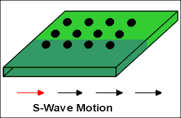
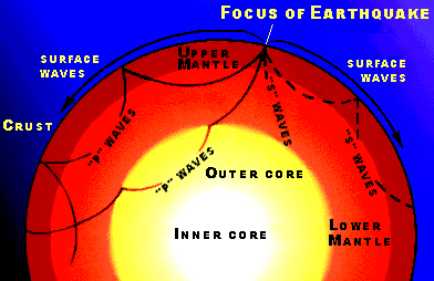
Geologists have determined that there are 3 distinct vibrations that
occur during an earthquake:
 |
 |
 |
Credit
USGS
These waves travel with different speeds through the earth. They
also bend (refract) as they move, depending on the nature of the material
they move through. P waves (also known as primary waves or
compression waves) create disturbances in the same direction in which they
propagate. A good example of a "P" wave is the motion you would expect if
one car rear-ends another car ... and that car, in turn, rear-ends the car in
front of them, etc. S waves (also called shear, transverse,
or secondary waves) create disturbances at right angles to the direction in
which they propagate. An example might be the familiar "wave" done by
spectators at sporting events. "S" waves do not go through liquids (one
way we know the outer core is liquid). Surface waves (also called
Q, L, or love waves) are restricted
to the upper crust and can cause the most damage (see animated image above
labeled L-Wave).
The Richter Scale - Developed by C.F. Richter at Caltech in 1935. Based on the amplitude of the surface (L) wave recorded at a station and adjusted for the distance from the quake. It is a logarithmic scale that goes from 0 -10. For every one full point change in magnitude, the amount of shaking recorded by a seismometer will go up by a factor of 10.
Recently, a new magnitude scale has been developed called the moment magnitude (a modification of the Richter Scale) which tells you something about the physical size of the earthquake. Using this scale, for each difference in magnitude, the energy released increases by a factor of 30 .. actually 32!!!). This means that a quake of magnitude 6 releases 30 times more energy than a magnitude 5 quake. Furthermore, a magnitude 7 releases 900 (30x30) times the energy of a magnitude 5 quake!!! As an example, recently people have gone back and recomputed magnitudes for earthquakes such as the 1964 Alaska earthquake. Previously, the magnitude had been given as 8.6, but nothing compared to the 9.2 which is now accepted (remember that magnitude scales are logarithmic). Moment magnitudes are now the accepted magnitude among seismologists, and are usually the numbers given to the press.
The largest earthquake
recorded this century was 9.5 (moment magnitude) in Chile, May 22,
1960.
At least three seismographic stations are needed to pinpoint the location of an earthquake. Each station finds the distance to the quake by relying on the fact that the "S wave" and "P wave" travel at different rates.
Speed of "P Wave" = 6 km/sec
Speed of "S Wave" = 3.5 km/sec
Difference in speed = 2.5 km/sec
The further you are from the epicenter, the greater the time gap between the arrival of the P wave and the S wave.
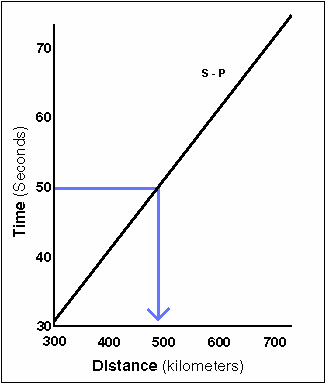
For example, if there is a 50 second difference between the arrival of the S waves and P waves, you would know (from the chart) that the epicenter was approximately 500 km away.
By using a method of triangulation, three seismographic stations can tell where an earthquake occurs. They can also estimate the magnitude based on the amplitude of the "S Wave" .
 (animation)
Almost all significant
earthquakes occur at plate boundaries
(the Mississippi River valley earthquakes of 1811-1812 including the
New Madrid earthquake in Missouri is a good exception - and still a big
mystery)
Click here to see where most earthquake occur in the world.
Click here to read about recent earthquakes.
Click here to see the most famous transform plate boundary - The San Andreas Fault.
The largest earthquake in Wisconsin was on May 6, 1947 in Milwaukee and was only 5 on the Richter Scale
| Descriptor | Magnitude | Average Annually |
|---|---|---|
|
|
|
|
| Major | 7 - 7.9 | 18 |
| Strong | 6 - 6.9 | 120 |
| Moderate | 5 - 5.9 | 800 |
| Light | 4 - 4.9 | 6,200 (estimated) |
| Minor | 3 - 3.9 | 49,000 (estimated) |
| Very Minor | < 3.0 | Magnitude 2 - 3: about 1,000 per day
Magnitude 1 - 2: about 8,000 per day |
Deaths by Earthquakes - click
here
(Note the quake of 1556 in China: most deadly earthquake in history; 830,000
killed (est.)
Click here to read about earthquake probability maps, hazards and ability to predict earthquakes.
Animal Behavior - Click here. Changes in animal behavior before earthquakes have been observed and documented in different parts of the world, most recently in the northern California earthquake of October 17, 1989. It has been recorded that a fish in a high school biology lab in California would flip on its side before some earthquakes. Dogs, cats, snakes, and horses has also been known to behave strangely before earthquakes. Since behavior is not earthquake specific, change in animal behavior can therefore result from other events, and it is impossible to determine beforehand what factor has caused the change. Also, the behavior is not consistent. Sometimes earthquakes occur with no previous behavior change.
Perhaps this effect will be studied in much more detail following the great tsunami of 2004. In that instance, there was a significant loss of human life, yet a very low loss of animal life. It has been well documented that animals sought high ground well in advance of the wave. How were they able to sense this?
Changes in the water table? There are reports that the water level in wells have dropped just prior to an earthquake. Is this just hooey or something that is a direct result of building stress on rocks?
One well known successful earthquake prediction was for the Haicheng, China earthquake of 1975, when an evacuation warning was issued the day before a M 7.3 earthquake. In the preceding months changes in land elevation and in ground water levels, widespread reports of peculiar animal behavior, and many foreshocks had led to a lower-level warning. An increase in foreshock activity triggered the evacuation warning. Unfortunately, most earthquakes do not have such obvious precursors. In spite of their success in 1975, there was no warning of the 1976 Tangshan earthquake, magnitude 7.6, which caused an estimated 250,000 fatalities.
Change in geyser eruption patterns - Perhaps the stress built up in an impending quake is enough to change the capacity (volume) of the water reservoir below the surface ... or even allow water to drain from the reservoir itself. This would change the predicted time of eruption.
Vladimir Keilis-Borok, a geophysicist at UCLA, has successfully predicted two large earthquakes by examining the 5 year history of the area. He noticed patterns of many smaller "cluster" earthquakes prior to the much larger quake. These predications were done in the second half of 2003 and he has even predicted a 6.4 earthquake will rock the Californian Mojave in the fall of 2004. When one hit in January, 2004 ... was he right or wrong (he gave a 9 month leeway in his original prediction)? Even Keilis-Borok admits he needs further testing before earthquake prediction becomes a reality. If interested, click here for the story.
![]() Geochemical
changes in water? A pair of geologists, Lillemore Claesson and
Alasdair Skelton, from Sweden found that concentration of metal ions in
groundwater rose dramatically weeks prior to the occurrence of an earthquake in
Iceland. The water was sampled from 1½ mile
deep wells. It was a bit of luck that just weeks after their
initial work, an earthquake occurred 60 miles away. They suspect that the
increase in concentration of metal ions occurred because stresses in rock
allowed much hotter (deeper) water to enter the wells (and you already know that
hot water can hold hold more ions in solution). Click
here to read more.
Geochemical
changes in water? A pair of geologists, Lillemore Claesson and
Alasdair Skelton, from Sweden found that concentration of metal ions in
groundwater rose dramatically weeks prior to the occurrence of an earthquake in
Iceland. The water was sampled from 1½ mile
deep wells. It was a bit of luck that just weeks after their
initial work, an earthquake occurred 60 miles away. They suspect that the
increase in concentration of metal ions occurred because stresses in rock
allowed much hotter (deeper) water to enter the wells (and you already know that
hot water can hold hold more ions in solution). Click
here to read more.
In any case, there is no official long term, established method of successfully predicting earthquakes at this time.
But one more thing is worth mentioning here. If an earthquake does occur, people living far from the epicenter can be warned, in advance. Recall that the "P Wave" travels at about 6 km/sec. That means that it would take 3 minutes before an earthquake reaches a distance of 1000 km (600 miles) from the epicenter. Could that save your life if you knew your house could fall down in 3 minutes? This would require an incredibly well organized civil defense system (although it wouldn't help much if you are very close to the epicenter ... and they would need it the most).

Tsunami of December 26, 2004 (animation)
On December 26, 2004 we all witnessed the power of the earth. Deep under the Indian Ocean, two oceanic plates are converging. As one plate subducts under the other, friction drags on and compresses the overlying plate, ... storing an enormous amount of energy in the process. Suddenly, it snaps, ... resulting in an earthquake of about 8.9. In addition, there is a huge vertical shift of the seafloor. This displaces a large volume of water, ... which initiates a series of waves, ... which travels thousands of miles. Sometimes called tidal waves (a poor name because tides have nothing to do with it), ... a tsunami wave can travel as fast as a jet airplane. Once it approaches shallower water, it amplifies in height. In areas with low relief coastlines, the wave can penetrate several miles inland. The result can be deadly, ... but is there a way to reduce the death toll? You bet.
A "tidal wave" can travel great distances from the epicenter and still cause great destruction. A Tsunami warning system would give several hours of warning before the wave surge hits. A tsunami warning system in the Pacific Ocean has shown that it can be highly effective. However, the disastrous tsunami of December 2004 has proved that an adequate warning system (at least in the Indian Ocean) was not in place.
This system consists of a series of "water height" sensors which rest on the ocean floor. Each sensor can measure the water pressure above its position. If a tsunami wave moves over the sensor, it records a sudden change in pressure. This information is relayed to a floating buoy, ... which relays the information to a satellite, .. which alerts scientists. The second part of the warning system is to educate people of the proper procedures to follow once the warning is issued. Did you know that tsunami usually produce several huge waves (and that the second or third wave may be larger than the first)?
For more on this relatively recent tragedy see topic #7 in the discussion board.
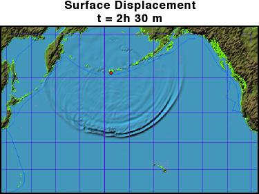
Image from NOAA
Other
Will California fall into the ocean? I hope by now you will be able to answer
this one on your own. Think about what kind of fault boundary you find in
California. Also, can you think of any kind of plate interaction
that would cause California to get pulled into the ocean?
Links:
http://www.ceri.memphis.edu/public/
©Jim Mihal 2004, 2006 - all rights reserved