The Oceans
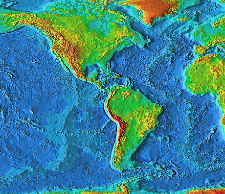
Credit NOAA
You (hopefully) already know quite a bit about the earth's oceanic crust.
You know:
-
Oceanic crust is basaltic and young
-
Oceanic crust is created at mid-ocean ridges creating a long chain of volcanic
mountains
-
Oceanic crust gets subducted (and destroyed) when it converges into continental
crust or younger (hotter) oceanic crust.
-
Subducted oceanic crust also creates deep ocean trenches - the Mariana
Trench is over 7 miles deep (Mount Everest is only 6 miles high).
-
The Hawaiian islands are created by magma emitted from a "hot spot" which
moves relative to the Pacific plate (creating a string of islands).
You also know
- The oceans plays a vital role in the hydrologic and carbon cycles.
Without oceans, both of these cycles would fail to provide a stable
environment necessary to support life.
- Life most likely got started deep in the oceans. The bacteria
derived their energy from sulfides (and methane) emitted from hydrothermal
vents. The oceans protected these ecosystems from harmful solar UV
radiation. In addition, life got started very early in earth's history
... a time when the surface was quite hostile (more of this in unit 5).
But did you know:
-
Oceans make up 71% of the earth's surface.
-
All this surface water helps to moderate the climate. This comes from the
high
specific heat capacity of water. That is, water is able to absorb
large amounts of solar radiation but only show small changes in temperature.
Folks living in Milwaukee are well familiar with this effect. The phrase
"cooler near the lake" is often added to summertime weather forecasts.
Without all the water covering our planet, the earth would experience much
greater global temperature swings on both long term (seasonal) and short term
(daily) time scales.
-
Each gallon of ocean water contains about one cup of dissolved salts.
-
It gets salty because salt easily dissolves in water. As water flows
over land in rivers and streams, it picks up salts in solution and concentrates
it in the oceans.
-
Some of the ocean's salts have been dissolved from rocks and sediments
below its floor. Other sources of salts include the solid and gaseous materials
that escaped from the Earth's crust through volcanic vents or that originated
in the atmosphere.
-
The flattest part of the earth is part of the ocean floor called an abyssal
plain. They lie away from the mid-ocean ridges and are created
by sediments which are several miles thick.
-
There is a major abyssal plain just off the eastern coast of the US
-
The organic rich sediments forming the plain will someday get converted
to petroleum.
-
There are under-sea volcanoes
or fissure eruptions which poc-mark the ocean floor called seamounts.
-
There are surface ocean currents, like the Gulf
Stream, which are driven by global winds (covered in the next unit).
The Gulf Stream
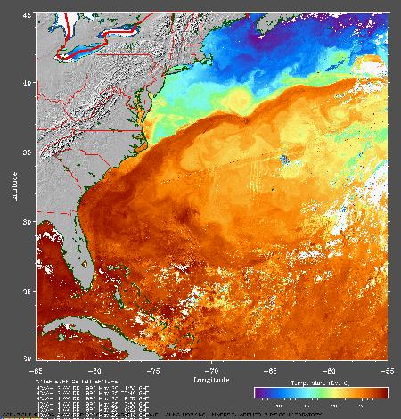
The Gulf Stream - Credit NOAA
-
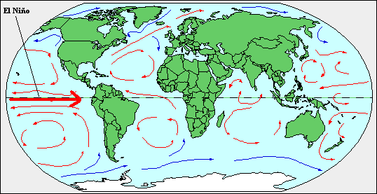
Surface ocean currents transport huge amounts of heat from the equator
to the poles.
-
Where a surface ocean current flows in an offshore direction, the surface
waters are replenished with water which flows up from greater depths in
the ocean. This is known as upwelling. It is common along the west
coasts of continents such as Africa, North America and South America. The
upwelling of deep water brings nutrients such as nitrates and phosphates
into the surface waters, promoting very high biological productivity. The
high plankton concentrations, in turn, promote large numbers of fish, whales,
seals etc. The world's best fisheries are found in regions of upwelling.
-
El
Niño is an event where warm surface ocean currents move eastward along the equatorial Pacific
toward South America. Unlike most surface ocean currents, this
intermittent event is not driven by global winds. In fact, El Nino does
just the opposite - it produces changes in global wind patterns which effects the climate. No one knows why it occurs, but its effects
are becoming understood.
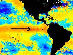
El Niño (red is warm water)
Credit NOAA
-
This surface current is from west to east ... just the opposite of the normal
trade wind directions (east to west) found in that region (this is
something covered in the next unit).
-
During times of a strong El Niño, the normal upwelling experienced
in the western coast of Central America is replaced by downwelling. This
event is devastating to the local fishing economy because the downwelling
suppresses the input of nutrients that fish require.
-
El Nino normally lasts a couple of months, and the fishermen could get
back to their business relatively quickly. In the past, it was rare for
El Niño to last for more than a year. Recently, however, El Niño has persisted
for several years at a time, and has been held responsible for dramatic
changes in climate patterns over half of the planet. There were major El
Niño events in 1982-1983 , 1997-1998, 2002-2003 and 2006. Each of these
episodes produced shifts in global wind patterns that provided Wisconsin with
mild winters and suppressed the formation of hurricanes in the Atlantic.
Oceanographers are trying to understand what causes El Niño and meteorologists
are trying to understand how El Niño affects the climate.
-
The opposite of El Niño is La
Niña (where surface currents are much colder) ... this effects the
climate as well, bringing things back to "normal".
Click here to
read about El Niño in 2003
The Topography of the Coastline
-
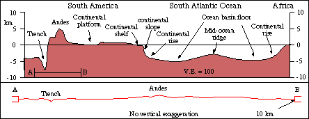
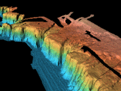
The boundary between the oceanic crust and the continental crust can be
abrupt ... especially at a convergent boundary. Notice the deep trench
located just west of the Andes Mountains (image above).
A mile high cliff of the west coast of Florida
seeking permission from Columbia
University
The Continental Slope off the eastern US coast
Notice the numerous, deep submarine canyons cut by sub-sea
avalanches (turbidity
currents)
seeking permission from Columbia
University
-
The boundary between the oceanic crust and the continental crust can be
more gradual ... especially at a passive boundary. It consists of:
- The Continental
Shelf - the extension of the continent itself below sea level. It is a
very gentle gradient (slope). Only a slight shift in sea level can
drastically alter the amount of land (mass above sea level) at these locations.
- The Continental Slope - a steep slope separating a continental shelf
and a deep ocean basin. It slopes all the way down to the flat abyssal
plain, which forms part of the deep ocean floor.
-
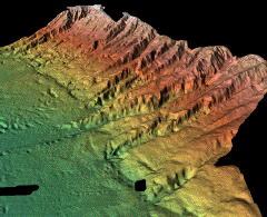
The continental slope is marked with huge submarine canyons created by
turbidity
currents (which is basically a landslide ...errr ... sea-slide of sediments
down the steep slope ... a huge underwater mass wasting event).
-
The Abyssal Plain then extends all the way to the Mid-Ocean ridges.
As you approach the ridge, the bedrock becomes younger with smaller amounts of
sediments on top.
-
At the Mid-Ocean Ridges new crust is formed as two plates diverge from
each other.
-
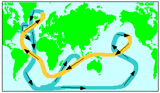
There are also deep
subsurface ocean currents which move slower than surface currents.
Much work is being
done to learn more about this aspect of the oceans. These deep ocean
currents are caused by variations in density of the ocean water. These
density variations are in turn caused by variations in temperature and
salinity - they are consequently called thermohaline currents. Cold
dense water is formed in the North Atlantic off Greenland and in
the southern oceans fringing Antarctica. This water then flows like a gigantic,
slow-moving conveyor belt through the Earth's ocean basins, taking over
1,000 years to complete one cycle.
Links
Great maps
of the ocean floor
©Jim Mihal 2004, 2006 - all rights reserved


