Actually there are three reasons why the poles are cold.
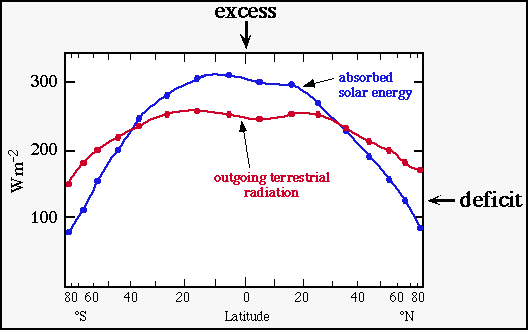
If this would continue, the equatorial region would get hotter and hotter and the polar regions of the earth would continue to get colder and colder. But in the long run, this does not happen. Why? because nature has found a way to transport the excess heat from the equatorial regions to the polar regions. Approximately 25% of this energy is transported by surface ocean currents (remember the gulf stream?). The bulk of this energy is transported by global winds.
The actual model is quite complex so let's take it in steps.
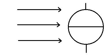
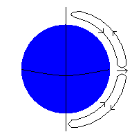
Simplest Model - Non-rotating earth with no land masses. Click here for an image or here for a smaller version. This is a simple convection cell of rising and descending air. Each cell encompasses an entire hemisphere. This model doesn't work well in reality ... but you have to start somewhere and build on it. About the only thing this model does predict is the area of rising air near the equator.
Can you see why there is a small cloud in the region of rising air (near the equator)?
More complex model - The earth starts spinning on its axis. Hang in there... it just got tricky.
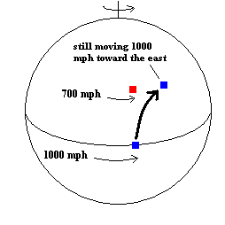
During W.W.II, the Germans developed a gun that could propel a shell 75 miles. When the Allies tried to destroy it with their own long distance guns their aim seemed to be off ..they kept missing to the right... because they forgot to take into account the Coriolis Effect due to the rotation of the earth. What is the Coriolis Effect? Objects in the northern hemisphere seem to deflect to their right (or to the left in the southern hemisphere). Why? An object resting at the equator is actually moving quite fast ... about 1000 mph eastward, in fact, because the earth spins that fast at the equator. Examine the diagram below. Suppose the blue dot over the equator is a rocket fired due north. When it is fired, it continues to maintain its eastward speed of 1000 mph (no matter where it is aimed). As it moves to higher and higher latitudes, it moves into locations that are moving slower and slower. For example, Milwaukee is moving at about 700 mph eastward because Milwaukee is closer to the pole (moves in a smaller circle ... even though you don't feel it .. so are you). What happens if a rocket (moving 1000 mph eastward) finds itself in a place where the earth is only going 700 mph eastward? The rocket will be going faster in the eastward direction than the ground it is moving over ... so it moves in that direction. So instead of moving due north, it actually moves north-east. It appears to be deflected to the right! This is the Coriolis Effect!
You should know this about the Coriolis effect: In the Northern Hemisphere, objects are deflected to their right (as they move through the air). The deflection is to the left in the Southern Hemisphere. The Coriolis Effect must be taken into account during the flight of airplanes and rockets.
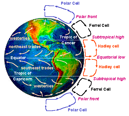
Global winds are subject to the Coriolis Effect too. In the northern hemisphere, winds are deflected to the right (to the left in the southern hemisphere). This complication splits this simple single cell circulation pattern into three separate convection cells.
Seeking permission from http://newmedia.avs.uakron.edu/geology/natscigeo/Lectures/climate/system.htm
Click here to see an image or here for a smaller version.
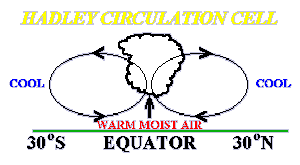
These separate convection cells (known as the Hadley Cell,
Ferrel Cell, and Polar Cell) set up surface winds as well.
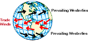
Notice in the "Hadley Cell" how the winds are deflected by the Coriolis effect to produce the Trade Winds. Also notice in the "Ferrel Cell" how the winds are deflected by the Coriolis effect to move in opposite direction as the trade winds. This is known as the Prevailing Westerlies.
Christopher Columbus knew about these wind patterns. He made his
trip to the "New World" sailing in the Trade Winds ... then returned in
the Prevailing Westerlies.
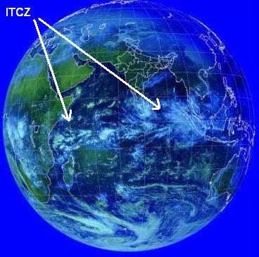
Image from Insat Satellite
The seasonal shifting of the direction of the sun's rays (due to the tilt of the earth's axis) also produces slight shifts in the location of the ITCZ. During the north hemisphere's summer (June, July & August), the ITCZ shifts above the equator. Six months later, the ITCZ is found below the equator. This shift of the ITCZ makes a dramatic change in the climate of India. During the (northern hemisphere's) winter, the ITCZ is south of India. The result is a northeast trade wind over India which brings dry air off the Asian continent.
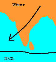
Dry season in India
However, during the (northern hemisphere's) summer, the ITCZ shifts over India ... bringing in warm moist air from the Indian Ocean. The results is the seasonal rain season called the monsoons. Note: In the case of the monsoons, another major variable is the unequal heating of water versus land which creates a huge low pressure system called the Tibetan Low. We will bring this up a bit later.
See how global patterns shift with the seasons:
Global wind circulation image
and global pressure image
from http://www.atmos.washington.edu/1999Q2/211/extra_material/js_ocean_atm_circ.html
Seeking permission from http://www.nps.gov/pub_aff/e-mail/
image
link
Land tends to break up the Subtropical High into isolated systems
Notice the two isolated high pressure systems located just off North and South America. This is what is left of the subtropical high (we just discussed). The location of the ITCZ is still considered low pressure (because it is between the highs). In fact, there is so much land in the northern hemisphere that many of the circulation patterns discussed earlier aren't even recognizable.
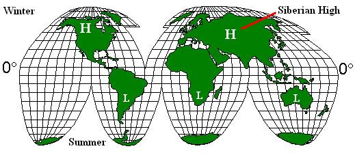
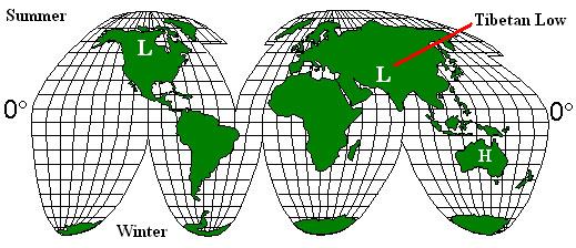
To make matters worse, the heating/cooling effects of land (versus water) can create isolated pressure systems (which sometimes outweigh any patterns already discussed). Generally speaking this is what can be said:
In winter, the land cools much more than the water it borders ... this creates isolated high pressure zones over the land. (Notice the two high pressure systems over Canada and Russia during winter depicted in the image below)
In summer, land heats up much greater than the water it borders ... this creates isolated low pressure zones over the land. (Notice the low pressure systems induced in South America, Africa, and Australia in the image below)
Thermally induced pressure systems
When the seasons reverse, so do these pressure patterns
Click this map ... see if you can find some classic examples. Hint: What is the pressure in Russia (and North America) during our winter. Look what happen to the Tibetan Plateau during the summer.
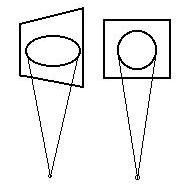
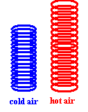
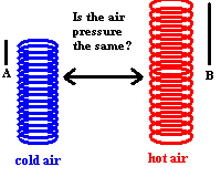
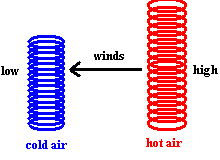
Why cold air produces a surface high pressure system.
First consider two identical columns of air except one contains hot air and the other cold air. The surface pressure (at the bottom of each column) would be identical (at first) because each column has the same amount of air in it. The only difference would be how the air is distributed within the column. Since cold air is denser, the column of cold air would be shorter than the column of hot air (which would extend higher into the atmosphere because warm air expands) ... but the surface pressure would be the same! Now consider what happens if you move to some height above the ground and look at the pressure of the air in each column. The middle image (below) has a black horizontal line pointing to each column. The question is: Will the air pressure in each column (at points labeled A & B) still be equal in the hot and cold air? Since air pressure is the amount of air above any point, the answer is NO! It should be clear from the diagram that there is less cold air (blue) above the line (at point A) than hot air (red) above the line (at point B). This means that if you look at any place above the ground, there will be horizontal pressure differences between adjacent columns of air (provided the two columns are at different temperatures). So what? Air responds to pressure differences ... in fact, that is what is needed to make wind. Air will flow from high pressure towards low pressure. So we have just created a mechanism for air to flow from the higher pressure hot air (red) ... toward the lower pressure cold air (blue). And this means we have now added more air to the cold air and removed air from the hot air. This, in turn, changes the surface pressure ... making it higher in the cold air and lower in the hot air. Now you have an idea why temperature differences can create pressure differences.
These pressure systems are initiated at the junction of the Ferrel Cell and the Polar Cell known as the Polar Front. Here warm surface air crashes head-on with cold polar air. The temperature contrast sets the stage for some interesting weather. If you followed the discussion above, you see that temperature differences can initiate upper air pressure differences. These same upper air pressure differences that help establish the Jet Stream. Why you get a this Jet Stream and how it produced pressure systems will be covered in the next section. You will also see how changes in the Jet Stream help establish these pressure systems ... stay tuned.
Great global winds link - click here
another great link - click here
©Jim Mihal 2004 - all rights reserved