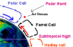
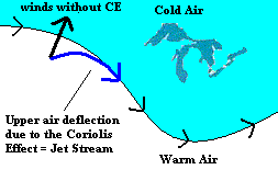
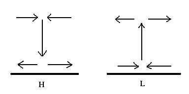
In the last section you saw how a rotating earth produced cells of atmospheric circulation. In this section we will concentrate on the location where the Polar Cell and Ferrel Cell clash ... known as the Polar Front. At the surface, cold dry artic air rams into warm moist tropical air. When that happen, it sets up some interesting events.
One byproduct of this clash is the jet stream. But what is the jet stream?
During all weather forecasts, they show a image of a long snake-like ribbon on a map of the US. They are showing you the current position of the jet stream (use the map option to locate jet stream maps) ... or click here if that doesn't work.
Images of the Jet Stream from the Weather Channel
The jet stream is a "river" of fast westerly winds situated directly over the Polar Front (and goes all around the globe). It is at the top of the Troposphere (about 6 mile up). The US first discovered it when they tried to retaliate against Japan during W.W.II after Pearl Harbor. In an effort to fly airplanes to Japan and conserve fuel, they took their airplanes to maximum height but met with excessive head winds ... the jet stream. Wind speeds in the jet stream are strongest in the winter. It is initiated by the strong contrast of air types between the Ferrel Cell and the Polar Cell.
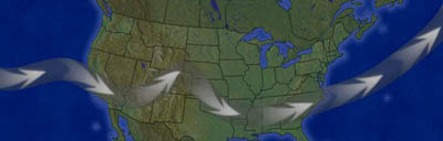
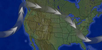
When the temperature contrast between these cells is less extreme, the jet stream is nearly horizontal. Meteorologists say that the flow is "zonal" (left image above). Typically there is not severe weather during zonal flow. However, when the contrast between the air masses is extreme, the jet stream picks up speed, surface lows are initiated (and can be intense), the jet stream meanders wildly (like a river), and generally we are in for a bad time (right image above). This is because the jet stream acts like a "barrier" ... preventing an easy mixture of contrasting air types (remember the transfer of heat from equator to pole?).
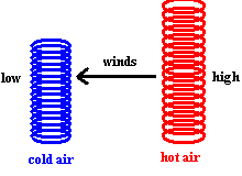
In the last section I tried to convince you that when warm air and cold air meet, there are upper air pressure differences between the two air columns. This difference in pressure will initiate the movement of air from one column to the other (winds) far above the ground. This is exactly what happens at the Polar Front. Except the winds never move from the warm air to the cold air ... they are deflected by the Coriolis Effect (to the right in the northern hemisphere) .... producing the Jet Stream.
Why is the Jet Stream so important? Because the air that moves in the stream is responsible for creating isolated pressure systems (mid-latitude cyclones ... low pressure systems and mid-latitude anticyclones ... high pressure systems) that we experience in Wisconsin. We will come back to the jet stream in a bit and complete the story ... but first let's talk a little about:
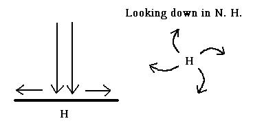
The next time an area of high pressure (anticyclone) passes by, pay close attention to the direction of the winds. You can always get this information from the weather channel.
Here is a question for you to ponder: In any isolated high pressure system, air is leaving the "column of air" and spreading away from the high). This should lower the surface pressure of the column itself (because air is being removed from the column) ... and the surface high should quickly dissipate. But it doesn't ... in fact, it may even strengthen! What are we missing here?
Also notice another function a surface high might have. Severe weather occurs when contrasting air masses clash. Since the winds descending from a surface high spiral outward at the surface, it "pushes apart" any contrasting masses of air that could lead to severe weather. It acts like a referee separating two boxers. This is not the case when looking at surface low pressure areas.
Think back to the video, Cracking the Ice Age. If you recall, the entire video dealt with the way carbon was removed from the atmosphere. It was initiated by increased rainfall around the Tibetan Plateau. It should be clear now why that happens. The intense heating of the Tibetan Plateau during the summer creates a strong thermally induced surface low (Tibetan Low). Can you guess how winds enter India from the Indian Ocean during the Monsoons? (Hint: The Trade Winds play second fiddle here). As surface winds rush into this low pressure system, the air moves upward ... expanding and cooling along the way .. until it reaches the dew point and the air becomes saturated. It rains almost every day in India during this period.
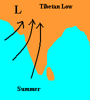
Summer Monsoons in India
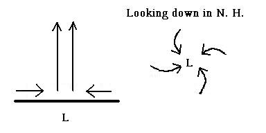
Here is another question for you to ponder: If air is drawing into the low, shouldn't it quickly fill up and dissipate? In fact, it may even intensify ... what are we missing?
The answer to both "ponder questions" comes from understanding what makes these systems in the first place. These surface pressure areas are initiated by the flow of air well above the surface. So the missing part of the puzzle is understanding what is happening in the jet stream. Air movement in the jet stream is very much like the movement of cars on the express way. If things are going smoothly ... cars are evenly spaced and moving at a steady pace. But what happens when you have someone off to the side of the road (for any reason) ... you get a "gaukers block". You slow down, cars pile up next to each other and you eventually pass the distraction and quickly speed up. In this region, cars are moving apart from each other and you are accelerating. Air in the jet stream does the same thing. Meteorologists call this upper air convergence (slowing down) and upper air divergence (speeding back up). When air in the jet stream piles up, it causes a high pressure system to develop at the surface (since you are adding air to the column). Some of the air is forced vertically downward and once it reaches the ground, it spirals outward in a clockwise motion (northern hemisphere). You should be able to use the same logic to account for the low pressure system that develops under an area of upper air divergence. The high pressure zones are called mid-latitude cyclones and the low pressure zones are called mid-latitude anticyclones.
Upper Air Convergence
Upper Air Divergence
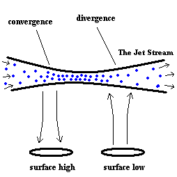
At the mid latitudes (around Wisconsin), these highs (anticyclones) and lows (cyclones) are not only initiated by the jet stream ... but "steered" by the jet stream ... and even strengthen or weakened by the jet stream (because it contains areas of converging and diverging air).
Generally speaking, when the jet stream is zonal (relatively straight) there is less variation in the flow of the jet stream and any surface highs and lows are usually not very intense. However, when the jet steam meanders wildly (becomes very wavy), the air in the jet stream undergoes more convergence and divergence. This, in turn, produces intense surface highs and lows.
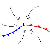
A warm front is depicted as a red line with semicircles and a cold front is depicted as a blue line with spikes. A warm front indicates that warm air is entering terrain once held by cold air. A cold front is forcing out warm air. Severe weather may occur along either front, but is most likely along a cold front.
As these low pressure systems move across the US, the shape and position of the fronts will adjust as well ...always moving in a counter clockwise direction ... with the cold front usually moving slightly faster around the low than the warm front. Pay attention to the "track" of an approaching low pressure system and notice how the fronts move relative to each other. It is interesting to pay attention to the passage of any fronts over your location and the types of weather you experience before, during and after the event.
 (animation)
Click here to see a current weather map of the US.
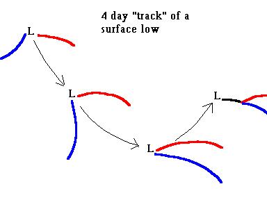
Meteorologists give names to different ways a surface low moves across the country. Two that effect Wisconsin are "Alberta Clippers" and "Panhandle Hooks".
An Alberta Clipper usually occurs in winter during a time when
the jet stream is zonal. It steers weak surface pressure systems in a
straight line from the direction of Alberta Canada (just above Washington
State). The noticeable thing about these systems is the speed they move
at. In one or two days they can race across the country.
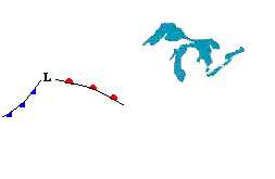
A Panhandle Hook is depicted in the image above. It occurs when the jet stream is meandering wildly ... steering with it intense surface lows that swing down from Canada to the Texas Panhandle and then back up towards Wisconsin. When that happens in winter, get your shovel ready.
Links -
Click here for more information - http://www.uwsp.edu/geo/faculty/ritter/geog101/modules/weather/cyclogenesis.html
©Jim Mihal 2004 - all rights reserved