When you stand outside on a star filled night, it can be a humbling experience. It can sometimes invoke questions about our role in the "big picture" which crosses philosophical and religious lines. The grandeur and vastness of the cosmos has had similar effect on man throughout the ages. As you stand and watch the night sky it is as if you were in the "inside" looking out! All the stars (to you) appear as distant points of light .... well beyond your reach. You have absolutely no depth perception ... so, as far as you are concerned, they could all be the same distance from you. You should already know that this in not true. The distance to stars may be vast, but it does vary from star to star. However, we will adopt this model of the universe for now because it allows us to treat the sky like a big sphere ... and you can draw lines on spheres and develop coordinate systems.
The Celestial Sphere
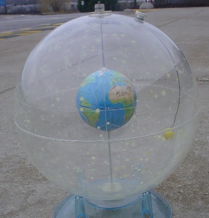
If you examine the image above, you will see that the "universe" is depicted with the earth at the center and all the stars lie on the "celestial sphere". Before we attempt to examine the lines astronomers draw on the celestial sphere, we should first review the ways geographers draw lines on the globe.
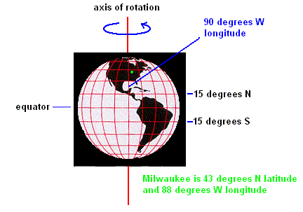
It is no secret that the earth spins on its axis. This motion is known as rotation. As it does so, it defines natural reference points such as the north and south poles. Midway between is the equator. Geographers draw horizontal lines on the earth which are parallel with the equator and then use these lines to determine the latitude of any given spot on the earth. The equator is the base line and is given a latitude of 0 degrees. Using this system, Milwaukee is 43 degrees north of the equator in latitude.
Lines are now drawn from the north pole to the south pole on the globe (known as meridian lines). These lines are used to determine the longitude of any point of the earth. By convention, the vertical line drawn through Greenwich England is chosen to represent the base line from which longitude is measured and is known as the prime meridian. Since Milwaukee is found 88 degrees west of the prime meridian, the longitude of Milwaukee is 88 West. Any point on the earth can be precisely located using coordinates of latitude and longitude.
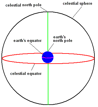
If you extend the earth's equator into the sky and project it onto the celestial sphere, it becomes a great circle known as the celestial equator. Likewise, extending the earth's axis of rotation to the sky defines the celestial poles (north and south). Astronomers use the celestial equator as a base line to measure objects in the sky in the north/south direction (similar to the way geographers use the earth's equator to determine latitude). This measurement, known as declination, is measured in degrees from the celestial equator. Positive numbers indicate north and negative numbers measure south of the celestial equator.
Declination
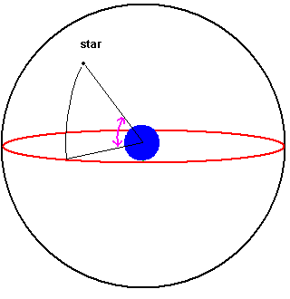
The vernal equinox is a point on the celestial equator that astronomers use as a reference for measuring east/west in the sky. The right ascension is the distance (measured along the celestial equator in an eastward direction) an object is displaced from the vernal equinox. The units are not in degrees but rather time units of hours, minutes, and seconds. As you might guess, it takes 24 hours to go a full 360 degree circle along the celestial equator (starting at the vernal equinox)
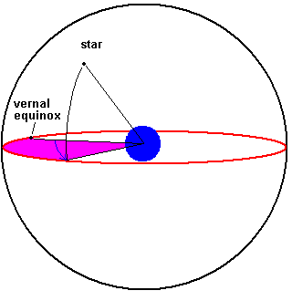
Right Ascension
Using this system of right ascension and declination, an astronomer can map the sky just as a geographer uses longitude and latitude to map the globe. If one only needs to obtain an approximate location in the sky, constellations will get you close. However, if you want an exact fix on an object, look up the objects declination and right ascension. Below are some coordinates of some stars as they might appear in a journal or astronomy book:
| Star | Declination | Right Ascension |
| Aldebaran | +16 30 33 | 04 35 55.2 |
| Arcturus | +19 10 57 | 14 15 39.7 |
| Antares | -26 25 55 | 16 29 24.4 |
+16 30 33 means 16 degrees, 30 arc minutes, 33 arc seconds (north) . An arc minute is 1/60 of a degree and an arc second is 1/60 of an arc minute. 04 35 55.2 means 4 hours, 35 minutes, 55.2 seconds east of the vernal equinox. Notice that the star Antares is south of the celestial equator.
East
Since it is quite impractical to work off a 3 dimensional celestial sphere, we can project the majority of the celestial sphere on a 2 dimensional surface.
Notice that the direction east is to the left. This is standard for all sky maps and you can see why if you simply look up as you face south. You will see that east is to your left. Note: The horizontal line across the center of the page represents the celestial equator with the vernal equinox at the exact center of the map.
Since we are standing on the earth, it becomes impossible to see the entire celestial sphere at once (unless you can see through the ground). In fact, from any one location on the earth and at any single time, you can only view half of the celestial sphere. This defines an observer's local horizon. Notice that astronomers are not concerned if it is day or night, flat or mountainous or even cloudy ... you always have half of the celestial sphere in your horizon. It should be obvious that your view of the celestial sphere depends on your location on the earth ... but it also (usually) depends on what particular time you happen to observing.
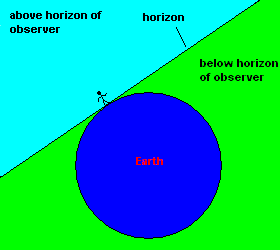
The earth blocks half our view of the celestial sphere.
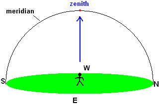
Your Local Horizon
There are some references to the local horizon that you should know. The zenith is the point directly over your head (straight up). The meridian (celestial meridian) is a line which extends from your northern horizon, through the zenith, and down to the southern horizon. The meridian divides the sky in half. Astronomers are always interested in knowing when objects are at or near the meridian because they are forced to view the sky through a thin atmosphere. However, when a celestial object is on the meridian, it passes through the least amount of atmosphere ... providing the best view of that object.
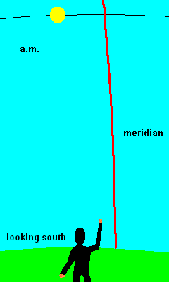
a.m. - p.m. animation
You make reference to the meridian almost each and every day. An appointment at 11:40 a.m., means "ante meridian" which is Latin for "before" the sun crosses the meridian ... and p.m. means "post meridian" which indicates the sun has past the meridian. Local noon (local apparent time or high noon) occurs when the sun crosses the meridian. At this time, a sundial would read 12:00 (we will see later that the wall clocks usually read something else).
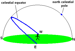
Milwaukeeans live about half way between the earth's north pole and equator and we see the sky a bit different than our neighbors to the north or south. Our latitude is 43 degrees north, and as a result, we find the north celestial pole 43 degrees above our northern horizon. This is not a coincidence ... the angle between the (north) celestial pole and the (northern) horizon will always equal your latitude! The celestial equator is always found 90 degrees from the north celestial pole. Using simple math, you should see that (in Milwaukee) the celestial equator is found 47 degrees above our southern horizon
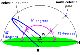
If you live in Canada, you would find the north celestial pole closer to the zenith. If you live in Mexico, the north celestial pole is found much closer to the northern horizon.
©Jim Mihal 2004 - all rights reserved